
Schwäbisch Gmünd (DE)
Category Urban - landscape - architectural
Location Hardt quarter
Population c. 59,700 inhab. - Hardt c. 2,900 inhab.
Strategic site c. 57 ha / ideas part 8 ha - Project site A: 1.18 ha / B: 1.20 ha / C: 0.67 ha / D: 0.56 ha
Site proposed by City of Schwäbisch Gmünd
Owner(s) of the site City, VGW (Schwäbisch Gmünd public housing authority), SVG (self-help housing society), county, state, private owners
Commision after competition Integrated urban planning development concept, implementation modules for sites A – D and the ideas part
Team representative architect - urban planner - landscape architect
More info
How can the site contribute to the adaptable city?
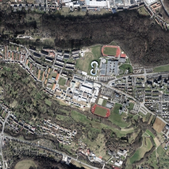
For a long time now, the city of Schwäbisch Gmünd has been committed to upgrading the former Hardt site (casern conversion) and has developed a master plan for buildings and open spaces that provides for redeveloping the site in parts. The teacher training college in the southeast and the vocational school centre in the northeast have been integrated into the Europan competition in order to explore synergies and ideas for a new urban model of the information society in the 21st century. The plan is to expand the existing buildings of the school to create social and cultural variety in the neighbourhood. The result should be a lively city neighbourhood with multiple functions and its own atmosphere; with public spaces that promote communication and understanding and give residents orientation and security.
City strategy
The “Gmünd 2020” plan is an integrated urban planning concept developed for the entire city. The Hardt area as a future urban renewal area is closely linked to the overall city development plan (urbanisation strategy). Between Hardt south and Hardt north, the Oberbettringer Strasse represents an urban split that is reflected in the population structure and the lack of connections between the two areas. The “green ribbon” in the master plan is intended as a linking element between the north and south sections, with green paths and open spaces intended to help the two neighbourhoods mesh with each other across the street. Planning of the “green ribbon” and surrounding construction is a crucial aspect of the tender. The north and south esplanades should also serve as a re-orientation within each neighbourhood and link the educational facilities.
Site definition
The site is located to the southeast of the city centre on a mountain spur. Most of the construction on the southern edge of the slope is single-family homes. The site is bordered in the east by the teacher training college and the vocational school centre. The zoning plan designates the area for use as residential, public facilities and special construction areas. The former US armed forces housing area in the north is characterised by housing blocks fanning out in east-west direction The area around the primary school and kindergarten should be complemented by social services and possibly shopping to become the social centre of the neighbourhood. In the southern portion of the site, the row houses along the north-south axis, built in the 1950s and 60s, constitute a self-contained neighbourhood in relation to the abutting tract of single-family homes.
Future of the site in relation to the site family and Adaptability
The approach to conceptual, urban planning and design solutions should contribute to strengthening the identity of the Hardt site. A crucial role in that will be played by improved integration and the creation of a social balance between Hardt south and Hardt north, achieved by upgrading the existing residential stock and its surroundings, as well as building new, contemporary housing. We are looking for an overall urban and landscape planning concept for the entire area that provides new momentum for better connections between the sectors and incorporates existing educational facilities into the overall concept. Of particular importance within the project area are the “green ribbon” and the esplanades as connective elements with the future neighbourhood centre with the Weltgarten (world garden) on the northeast border, a Gmünd citizen initiative to improve the multi-cultural neighbourhood), the planned village green in the north and the residential section Sonnenhügel (sunny hill) in the south. In the medium term, the construction yard site offers the potential to integrate a college campus and is an essential component of the idea. Concrete architectural suggestions for the project sites must be submitted. There should be a re-thinking of the structure of the centre of the neighbourhood with regard to retail shops between Falkenberg Square, the neighbourhood centre and the new college campus. A refinement of the residential surroundings is also crucial for the submission – new designs for street and open spaces, as well as re-organisation of the parking situation. Design measures should reduce the sense of a barrier presented by the Oberbettringer Strasse and clearly counteract its current character solely as a through street. The ultimate goal is sustainable development of the Hardt site that takes social, cultural, environmental and economic issues equally into account and ensures high urban planning standards, using innovative technology to accommodate environmental protections.
Lokality Europanu:
 Belgique Belgique |
| Libramont |
| Category Town planning and architecture |
| Charleroi |
| Category Town planning and architecture |
 Deutschland Deutschland |
| Marl |
| Category Urban - landscape - architectural |
| Bamberg |
| Category Urban - landscape - architectural |
| Gera |
| Category Urban - landscape - architectural |
| Schwäbisch Gmünd |
| Category Urban - landscape - architectural |
| Selb |
| Category Urban architectural |
| Ingolstadt |
| Category Urban – landscape – architectural – traffic – sociology |
| Landsberg |
| Category Urban - landscape - architectural |
| Feldafing |
| Category Urban - landscape - architectural |
 España España |
| Irun |
| Category Urban |
| Barcelona |
| Category architectural |
| A Coruña |
| Category Urban - architectural |
| Palma |
| Category Urban - architectural |
 France France |
| Bondy |
| Category Urban - architectural |
| Goussainville |
| Category Urban - architectural |
| Marne-la-Vallée |
| Category Urban - architectural |
| Saint-Brieuc |
| Category Urban - architectural |
| Metz |
| Category Urban |
| Montreuil |
| Category Urban - environmental - architectural |
| Moulins |
| Category Urban - environmental - architectural |
| La Corrèze |
| Category Urban - architectural |
| Bordeaux |
| Category Urban planning - architectural |
 Hrvatska Hrvatska |
| Zagreb |
| Category Urban - architectural |
 Italia Italia |
| Molfetta |
| Category Urban - architectural |
 Kosovo Kosovo |
| Gjakova |
| Category Urban - architectural |
 Nederland Nederland |
| Leeuwarden |
| Category strategic - urban - architectural |
| Streefkerk |
| Category urban - architectural |
 Norge Norge |
| Trondheim |
| Category urban - architectural |
| Ørsta |
| Category urban - architectural |
| Bergen |
| Category urban - architectural |
| Os |
| Category urban - architectural |
| Stavanger |
| Category urban - architectural |
 Österreich Österreich |
| St Pölten |
| Category urban - architectural |
| Wien |
| Category urban - architectural |
| Graz |
| Category architectural urban scale |
| Bruck/Mur |
| Category urban - architectural |
| Linz |
| Category urban - architectural |
 Polska Polska |
| Warszawa |
| Category Architectural - landscape |
 Portugal Portugal |
| Santo Tirso |
| Category urban - architectural |
| Barreiro |
| Category landscape - architectural |
| Azenha do Mar |
| Category urban - architectural |
 Suisse Suisse |
| Genève |
| Category urban - architectural |
 Suomi - Finland Suomi - Finland |
| Seinäjoki |
| Category urban - architectural |
| Jyväskylä |
| Category urban - architectural |
| Espoo |
| Category urban - architectural |
 Sverige Sverige |
| Nacka |
| Category urban - landscape - architectural |
| Lund |
| Category urban - landscape - architectural |